What Is a Map Quiz? Formats, Types, and Tips
Learn what a map quiz is and how it enhances geography learning. Discover formats, types, and tips for maximizing your quiz experience.
- types of map quizzes
- what is a map quiz
- what are map quizzes used for
- best map quiz resources
- importance of map quizzes
- map quiz strategies
- map quiz definition
On this page

A map quiz is an interactive educational tool that tests your ability to identify countries, cities, landmarks, or physical features by clicking or pointing directly on a map. These quizzes appear across all educational levels, from elementary school geography classes to adult trivia nights, and they do something passive map reading simply cannot: they force your brain to actively retrieve spatial information. Platforms like Seterra and Sporcle have built entire communities around this format. The result is a learning experience that builds real geographic knowledge, not just a vague sense of where things are.
What is a map quiz, exactly?
A map quiz is defined as an interactive geography test where participants identify places or features on a map rather than answering text-based questions. That distinction matters. When you click on where you think Nepal sits, you are building a spatial memory, not just recalling a word. The format pushes you past rote memorization into active spatial recall.
Most map quizzes cover three broad categories: political geography (countries, capitals, borders), physical geography (rivers, mountain ranges, deserts), and thematic geography (climate zones, population density, economic data). Each category trains a different mental skill. Knowing that the Amazon River exists is one thing. Knowing where it sits relative to the Andes is another.
Popular quiz sites like Seterra offer hundreds of free map-based exercises, while Sporcle layers in timed challenges and leaderboards. Both approaches share the same core mechanic: you see a map, you get a prompt, and you click. Simple in concept, genuinely challenging in practice.
How do map quizzes work?
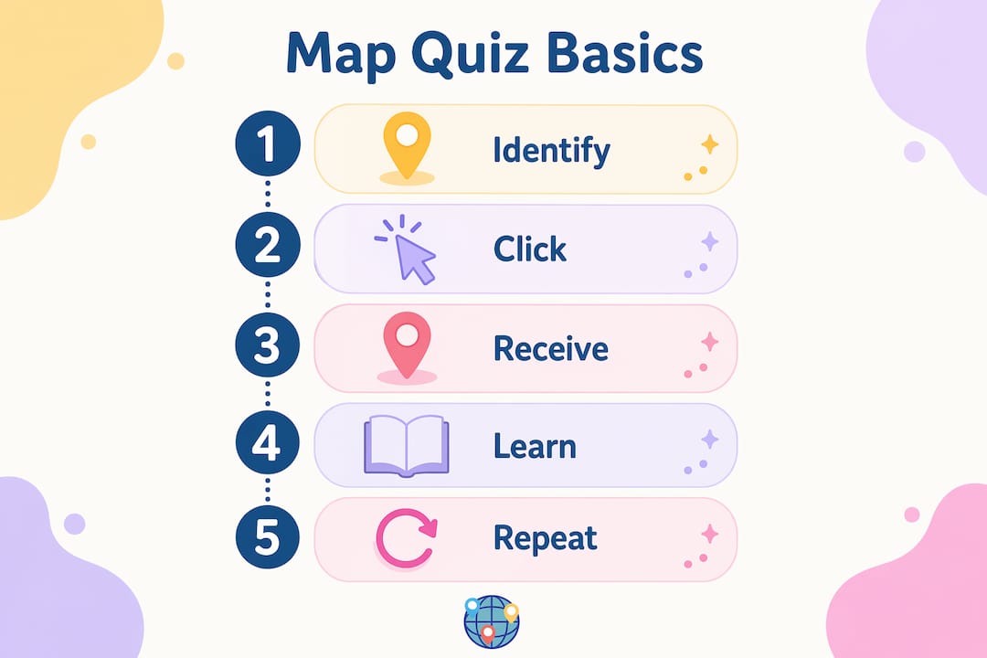
Digital map quizzes run on a click-based system. You see a blank or labeled map on screen, receive a prompt (like “click on Morocco”), and select the location you think is correct. The quiz then scores your answer based on an acceptance radius, which is the geographic zone around the correct location that still counts as a right answer.
Acceptance radius varies by feature size: large countries like Russia or Canada have wide radii, while small landmarks or city-states require near-perfect precision. This system keeps quizzes fair without making them frustrating. A near-miss on Luxembourg still teaches you something.
The main quiz formats you will encounter include:
- Outline quizzes: A country or region is highlighted, and you name it.
- Location quizzes: You receive a name and click where it belongs on the map.
- Thematic quizzes: You match geographic data (like rainfall or GDP) to regions.
- Timed challenges: Timed quizzes like identifying 43 European nations give you a fixed window, often around five minutes, to test recall speed under pressure.
Immediate feedback is the feature that separates map quizzes from paper tests. When you click the wrong spot, the quiz shows you where you landed and where the correct answer was. That near-miss signal is a powerful learning cue. Your brain registers the gap and adjusts.
Pro Tip: If a quiz shows you missed by just a small distance, do not skip past it. Pause for two seconds and visually anchor the correct location before moving on. That brief moment of correction does more for retention than reviewing a map passively for ten minutes.
What are the main types of map quizzes?
Map quizzes fall into three core types: political, physical, and thematic. Each one builds a different layer of geographic understanding.
| Quiz type | What it tests | Best for |
|---|---|---|
| Political | Countries, capitals, borders, territories | Recognizing nations and their relationships |
| Physical | Mountains, rivers, deserts, coastlines | Understanding terrain and natural geography |
| Thematic | Climate, population, language, economics | Connecting geography to real-world data |
Political map quizzes are the most common starting point. You identify countries by shape or location, name capitals, or trace borders. These quizzes build the foundational layer of geographic knowledge that everything else sits on top of.
Physical map quizzes go deeper. You locate the Himalayas, trace the Nile, or identify the Sahara’s boundaries. This type trains you to read the land itself, not just the political lines drawn across it. Physical geography explains why cities exist where they do and why borders often follow rivers or mountain ranges.
Thematic map quizzes are the most analytical. They ask you to connect geographic locations with data: which region has the highest population density, which countries share a climate zone, where does a specific language dominate. Combining all three types builds what geographers call spatial reasoning, the ability to understand places as interconnected systems rather than isolated dots on a map.
Mnemonic devices work especially well for political quizzes. Grouping countries by region, shape similarity, or shared borders gives your memory a structure to hang facts on. Spaced repetition, reviewing material at increasing intervals, locks those mnemonics into long-term storage.
Proven strategies for succeeding at map quizzes
Getting better at map quizzes is less about raw intelligence and more about how you practice. These strategies make a measurable difference.
-
Use blank maps for active recall. Blank map drills move geographic data from short-term to long-term memory through repeated retrieval without any visual hints. Staring at a labeled map is passive. Filling in a blank one is active. The difference in retention is significant.
-
Start with questions you know. Speed and confidence improve when you tackle easy questions first. Building early momentum keeps you calm and prevents the time-pressure spiral that causes careless errors on harder questions.
-
Check the compass rose before you click anything. Map orientation is a simple but often overlooked step. Some quizzes use non-standard orientations or regional projections. Verifying north, south, east, and west before you start prevents directional mistakes that have nothing to do with your actual knowledge.
-
Use mnemonic devices and spaced repetition together. Create a memory hook for tricky locations (the shape of Italy looks like a boot, Vietnam runs along the eastern edge of Southeast Asia like a long spine) and then review those hooks at increasing intervals. The combination of a vivid cue and spaced review is the most efficient path to retention.
-
Try physical map tools. Interactive and physical map puzzles engage different brain areas than screen clicking. Placing a physical pin on a map or assembling a puzzle of South America activates tactile memory pathways that digital quizzes alone do not reach.
-
Practice coordinate conventions. Latitude comes before longitude. Always. Under quiz pressure, this convention trips up even experienced players. Drilling it as a reflex prevents the kind of avoidable mistake that costs points on timed tests.
Pro Tip: Mix quiz types in a single study session. Do a political quiz, then a physical one covering the same region. The contrast forces your brain to build connections between political borders and the terrain underneath them, which is exactly how real geographic understanding works.
You can find a solid breakdown of map-based quiz formats that covers both educational and game-focused approaches, which is useful when you want to pick the right format for your goals.
How interactive map quizzes build real geographic knowledge
Map quizzes do more than test what you already know. They actively build new knowledge through the process of attempting answers.
“True map literacy requires active recall and spatial reasoning, not just passive observation.” The moment you click on a map and receive feedback, you are doing geography, not just reading about it.
Immediate feedback on near-misses is the key mechanism here. When you click 200 miles east of the correct location, the quiz shows you the gap. That visual correction creates a stronger memory trace than simply reading the right answer. Your brain registers the error, the correction, and the spatial relationship all at once.
Game mechanics amplify this effect. Timed challenges, score streaks, and difficulty levels give you a reason to keep playing past the point where passive studying would have stopped. Timed and clickable quizzes add engagement that sustains practice sessions long enough for real learning to happen.
The deeper benefit is a shift in how you think about geography. After enough map quiz practice, you stop seeing countries as isolated names and start seeing them as neighbors with shared histories, borders, and physical features. That is the difference between knowing where Chad is and understanding why it borders both Libya and Nigeria. Worldlecity’s daily city guessing game pushes this further by training you to read visual clues from photographs, which connects spatial memory to real-world recognition. If you want to sharpen that skill, the guide on identifying cities from photos is worth your time.
Key Takeaways
Map quizzes build genuine geographic knowledge through active recall, immediate feedback, and varied formats that train both spatial reasoning and real-world recognition.
| Point | Details |
|---|---|
| Map quiz definition | A map quiz tests geographic knowledge by having you identify locations directly on a map. |
| Three core types | Political, physical, and thematic quizzes each build a different layer of geographic skill. |
| Acceptance radius | Scoring flexibility is built in, with larger features allowing wider click margins than small ones. |
| Active recall wins | Blank map drills outperform passive map reading for long-term retention every time. |
| Game mechanics matter | Timed challenges and immediate feedback keep practice sessions engaging and effective. |
Worldlecity: put your map knowledge to the test
Ready to see how your geography actually holds up? Worldlecity turns that question into a daily challenge.
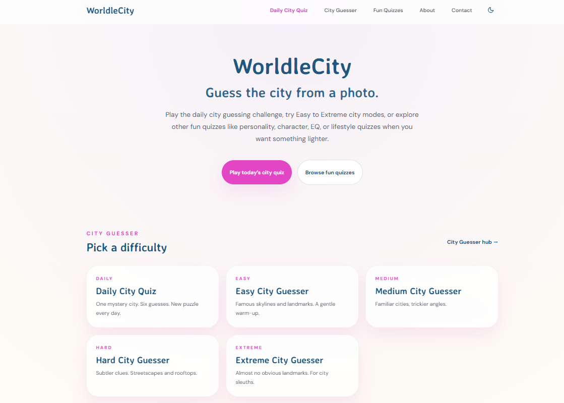
Each day, Worldlecity gives you a photograph of a mystery city and six attempts to guess it. Every guess comes with directional and distance feedback, so you are learning with each try, not just guessing blindly. You can also work through city guesser quizzes across four difficulty modes at your own pace, no account required. It is the kind of low-pressure, high-reward practice that makes geographic knowledge stick. Head to Worldlecity and take on today’s city challenge.
FAQ
What is the map quiz definition in simple terms?
A map quiz is an interactive test where you identify geographic locations, such as countries, capitals, or landmarks, by clicking or pointing on a map. It trains spatial recall rather than simple name memorization.
How do you take a map quiz online?
You open a quiz on a platform like Seterra or Sporcle, read the location prompt, and click the correct spot on the digital map. The quiz scores your answer based on an acceptance radius and gives you immediate feedback.
What are map quizzes used for?
Map quizzes are used in schools, trivia competitions, and self-study to build geographic literacy. They appear across all educational levels and help learners connect place names to actual spatial locations.
What is the best strategy for map quiz games?
Active recall with blank maps outperforms passive review. Start with questions you know, check map orientation first, and use mnemonic devices paired with spaced repetition for the best results.
What are the main types of map quizzes?
The three main types are political (countries, capitals, borders), physical (mountains, rivers, terrain), and thematic (climate, population, economic data). Each type builds a different geographic skill set.