Estimate Map Distance in 10 Seconds
Measure map distances fast: quick Google Maps clicks, browser calculators for GPX exports, and a WorldleCity drill to sharpen your distance instinct.
- estimate distance on map
- measure distance with Google Maps
- road distance vs straight-line distance
- map scale explained
- GPX distance calculator tools
- WorldleCity distance training
On this page
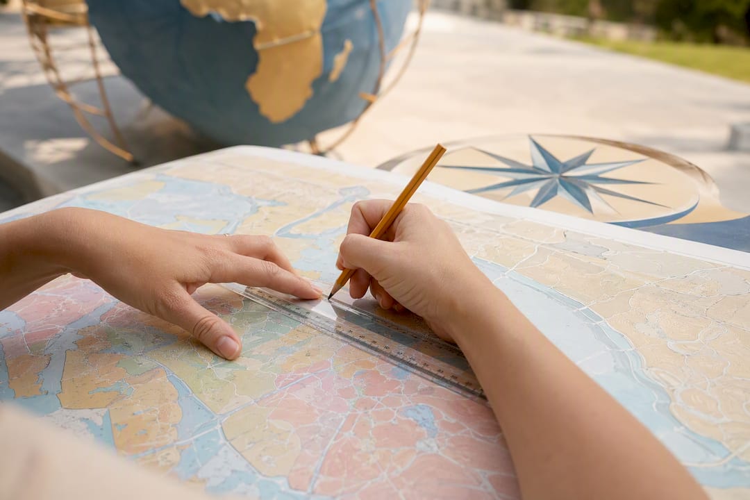
Three tools, three jobs. Google Maps handles a fast point-to-point check: drop two pins, right-click, done. A browser distance calculator earns its keep when you need elevation, a GPX export, or a full route plan. Stuck with a paper map? You’re back to a scale bar and a ruler. Whichever one you reach for, remember the number it gives you is not the number you’ll actually drive: straight-line distance and road distance are rarely the same, and the gap can be large.
TL;DR:
- Google Maps provides quick and accurate straight-line distance measurements, but it does not account for actual road or route distances.
- Browser distance calculators use the Haversine formula for accurate straight-line distance, and layer on elevation profiles and export options suitable for planning complex trips.
- Manual estimation with paper maps is limited by scale understanding and can introduce errors, especially on maps with larger denominators like 1:250,000.
- Road distances are typically 20% to 60% longer than straight-line distances, making routing tools essential for accurate planning.
- Using different mapping tools depends on your goal; topographic maps reveal elevation and terrain, while navigation maps reflect real-world travel distances.
Which tool should you use to estimate distance on a map?
Picking the right tool comes down to what you’re actually trying to find out. A straight line between two dots tells you one thing. A route with turns, hills, and stoplights tells you another.
Here’s the quick breakdown:
- Google Maps — best for fast straight-line checks or a rough multi-point path. It’s already on your phone and most laptops, so there’s no new app to learn.
- Browser distance calculators — best when you want the route saved somewhere useful. These tools tend to offer GPX/KML export, elevation profiles, and travel-time estimates for walking, cycling, or driving.
- Route planners and fitness tools — best for pacing a hike or ride. They factor in elevation gain and let you push a finished route straight to a GPS watch or bike computer.
If you just want to settle a bar argument about how far it is from Chicago to Milwaukee, Google Maps is overkill in the good way. If you’re mapping next month’s backpacking loop, you want the calculator with the elevation chart.
How do you measure distance in Google Maps?
The desktop version is the fastest path here, and it barely takes ten seconds once you know where to click.
- Right-click anywhere on the map. Select Measure distance from the menu.
- Click a second point to draw a line. The distance appears at the bottom of the screen, in miles or kilometers.
- Click additional points to build a multi-leg path instead of a single line.
- Drag any marker to fine-tune its position. No need to start over.
- Click a marker and hit the trash icon to remove just that point.
Google Maps’ own support page confirms this measures straight-line, not road, distance. It also flags a real gotcha: Lite mode, triggered by the little lightning bolt icon on slow connections, disables the measuring tool entirely. On mobile, the process is a bit clunkier: long-press a point, then tap “Measure distance” from the pop-up, and dragging markers works but feels less precise on a small screen.
Pro Tip: Place rough points first to sketch the whole path, then zoom in and nudge each marker into its exact spot. It’s faster than trying to click the first time perfectly.
When should you use a browser distance calculator instead?
Google Maps gets you a number. A dedicated distance calculator gets you a usable file.
These browser-based tools typically compute straight-line distance using the Haversine formula, which accounts for the Earth’s curve, so long-distance measurements stay accurate instead of drifting off on a flat projection. Beyond the math, they usually add:
- GPX or KML export you can hand off to a GPS unit or fitness app
- Elevation profiles, useful for judging how brutal a hike or ride will actually feel
- Travel-time estimates broken out by walking, cycling, or driving pace
Reach for one of these when you’re planning something with multiple stops, need a file you can import elsewhere, or want elevation data a simple straight-line tool won’t show you. A typical workflow: draw your route point by point, confirm you’re reading miles or kilometers (not nautical miles, an easy mix-up), then export the GPX and load it onto your device before you head out.
How does map scale help you estimate distance by hand?
No app, no problem, as long as you understand scale. Every printed map states its scale in one of three ways: fractional (1:50,000), graphic (a little ruler bar), or verbal (“1 inch equals 1 mile”).
A fractional scale is the one that trips people up. On a 1:100,000 map, 1 centimeter equals 1 kilometer on the ground. US topographic maps commonly use 1:24,000, which packs in far more detail than a highway atlas.
To measure by hand:
- Lay a ruler or a piece of string along your route, following every curve rather than cutting straight across.
- Mark the length against the graphic scale bar, or convert using the fractional ratio.
- Double-check your units before doing the math. Centimeters to meters and inches to miles are the two conversions that trip up almost everyone.
One rule worth memorizing: the bigger the denominator, the smaller the scale, and the less detail you get. A 1:250,000 map shows a whole region but hides small trails; a 1:24,000 map shows individual switchbacks but covers a tiny area.
Straight-line distance vs. road distance: what’s the real difference?
Straight-line distance (also called great-circle or aerial distance) is the shortest path between two points, ignoring every road, river, and mountain in between. Road distance follows what you’d actually drive or walk, which is longer almost every time.
Road distances typically run 20% to 60% longer than straight-line distance, depending on terrain and how the local road network is laid out.
These are ballpark multipliers, not guarantees. For anything longer than a quick errand, run it through a routing tool before you commit to a departure time.
How do you avoid mistakes when plotting points?
Small habits separate a solid estimate from a wildly wrong one.
Zoom in before you click. A marker placed at street level lands far more accurately than one dropped while the whole city is visible. If a point is slightly off, drag it; don’t clear the whole route and start fresh; using the undo or drag function saves real time over rebuilding from scratch.
Know whether your tool snaps to roads or draws a raw straight line. The two produce very different numbers for the same two points. Also check your unit setting once at the start. Nobody wants to plan a “12” hike that turns out to be 12 kilometers, not miles.
Pro Tip: Watch for bridges, ferry crossings, or trail closures that a straight line glosses right over. A river with no bridge nearby can turn a “short” route into a much longer detour.
Do different map types need different measuring approaches?
Not every map plays by the same rules, and the type in front of you changes how you should trust its numbers.
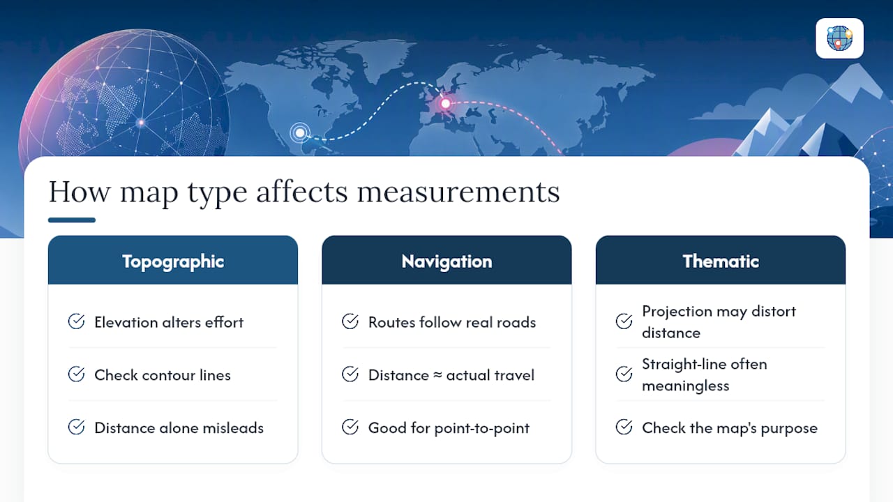
Topographic maps, like the USGS’s 1:24,000 series, pack in elevation contour lines alongside distance, so a route that looks short on paper might climb 2,000 feet along the way. Distance alone won’t tell you how hard a hike actually is; check the contour lines too.
Navigation maps, the kind built for driving or transit, already route along real roads, so the number they show usually reflects actual travel distance rather than a straight line. That’s the type where Google Maps’ point-to-point tool overlaps most closely with what a GPS would report.
Thematic maps, such as population density maps, weather overlays, or election result maps, often use a projection or scale distorted specifically to make their theme clearer rather than to preserve accurate distance. Measuring a straight line on a heavily stylized thematic map can produce a number that’s technically correct but practically meaningless if the underlying projection stretched the geography. Before you trust any measurement, glance at the map’s stated purpose. A projection built for showing subway lines is not built for judging real-world mileage. If you want a deeper look at how projections warp distance and shape, Worldlecity’s guide to map projections breaks down why a flat map can never perfectly represent a round planet.
Why do manual distance estimates go wrong?
Even careful measuring has built-in error, and knowing where it creeps in saves you from trusting a bad number.
The most common mistake: confusing straight-line distance for travel distance. A tool that quietly reports aerial distance can make a trip look 30% shorter than it really is, and most people never notice until they’re already driving.
Scale misreads are the second big source of error. Misjudge a fractional scale, or mix up centimeters and inches, and every measurement downstream inherits that mistake. A shaky hand with a ruler or string adds a smaller, but real, layer of error too, especially on winding coastlines or trail switchbacks where a straight ruler edge cuts corners a real path would never take.
Paper maps carry a scale-related limit as well: a 1:250,000 map physically can’t show the small detours a 1:24,000 map can, so any measurement taken from it is already a simplification. Digital tools fix a lot of this by snapping to actual roads or trails, but even they inherit GPS or satellite imagery errors, usually small, but never exactly zero. Treat any manual estimate as a good approximation, not a guarantee, and confirm anything time-sensitive with a routing tool before you rely on it.
Where does distance estimation actually matter in real life?
Estimating distance isn’t just a map nerd’s hobby. It quietly shapes decisions across a handful of fields.
Hikers use it to judge whether a “short” trail description matches reality once elevation and switchbacks get factored in, which is exactly why elevation profiles matter more than raw mileage for planning a day out. Urban planners lean on distance estimates to decide how far apart to place bus stops, schools, or fire stations, since a half-mile that looks fine on a flat map might mean a brutal uphill walk in practice. Logistics companies run distance calculations at massive scale, estimating driving distance between warehouses and delivery addresses to route trucks efficiently, where even a few percentage points of error compounds fast across thousands of daily deliveries.
Even casual travelers benefit: knowing that “close on the map” doesn’t always mean “close in the car” helps you build a realistic day trip instead of an overly ambitious one. The tool changes, but the underlying skill, reading a map and translating it into a number you can actually plan around, stays the same whether you’re a city planner or someone mapping a weekend hike.
Sharpen your eye for distance the fun way
Here’s a trick worth stealing: you can train your gut sense of distance the same way you train anything else, through repetition with quick feedback. That’s basically what Worldlecity’s city guessor quiz does. Guess a location, see how close you landed, adjust, repeat.

Try a quick drill: eyeball the distance between two cities in your head, then check it with a real tool. Do that a dozen times and your instinct for “how far is that, really” gets noticeably sharper. Pair those visual guessing reps with actual measurement, and you’ll start reading maps the way someone who’s done this a thousand times does.
If you want to put that instinct to the test daily, Worldlecity’s daily city guessing game gives you a real photo and six guesses to nail the location, with proximity and direction hints after each try. It’s free, no account needed, and honestly a pretty satisfying way to kill five minutes while getting better at exactly the skill this whole article is about.
For bearings specifically, Worldlecity’s GeoAngles is a closer match to what this article covers than the daily game. It gives you four known cities with arrows pointing outward from a hidden mystery city, and reveals the mystery city’s distance in stages, a color band first, then a rounded-to-500-km ring, then the exact number, as your guesses run out. Reading that ladder and narrowing a location from several outward bearings is a version of the same estimation skill this article walks through with a ruler and a scale bar.
Sources
- Measure distance between points - Computer
- Maptools
- What is map scale? | Geoscience Australia
- Map Scales (USGS fact sheet)
FAQ
Can Google Maps estimate distance?
Yes. Right-click any point on the desktop version, choose “Measure distance,” and click a second point to see the straight-line distance in miles or kilometers. It won’t work if Lite mode is active.
Can you measure distance on Apple Maps?
Apple Maps doesn’t have a dedicated built-in distance-measuring tool the way Google Maps does. For that feature, a browser distance calculator or Google Maps itself is the more reliable option.
How do you visually estimate distance on a map without measuring?
Compare the gap between your two points to the map’s scale bar using your eye or a spread finger as a rough ruler, then double it or halve it as needed based on how the scale bar looks. It’s a rough method best paired with a quick check using an actual measuring tool afterward.
Why can’t I measure distance on Google Maps?
The most common cause is Lite mode, which Google Maps automatically enables on slow connections and which disables the measuring feature entirely. Switching to a faster connection or toggling off Lite mode, shown as a lightning bolt icon, should restore it.