How to Identify Cities from Photos by Eye: A Practical Guide
Learn to identify cities from photos by eye: signs, road rules, architecture, street furniture, people and shadows, decoded step by step on a real photo.
- City identification from photos
- Visual clues in photos
- Street sign clues
- Architecture clues
- People and clothing clues
- Photo geolocation
On this page
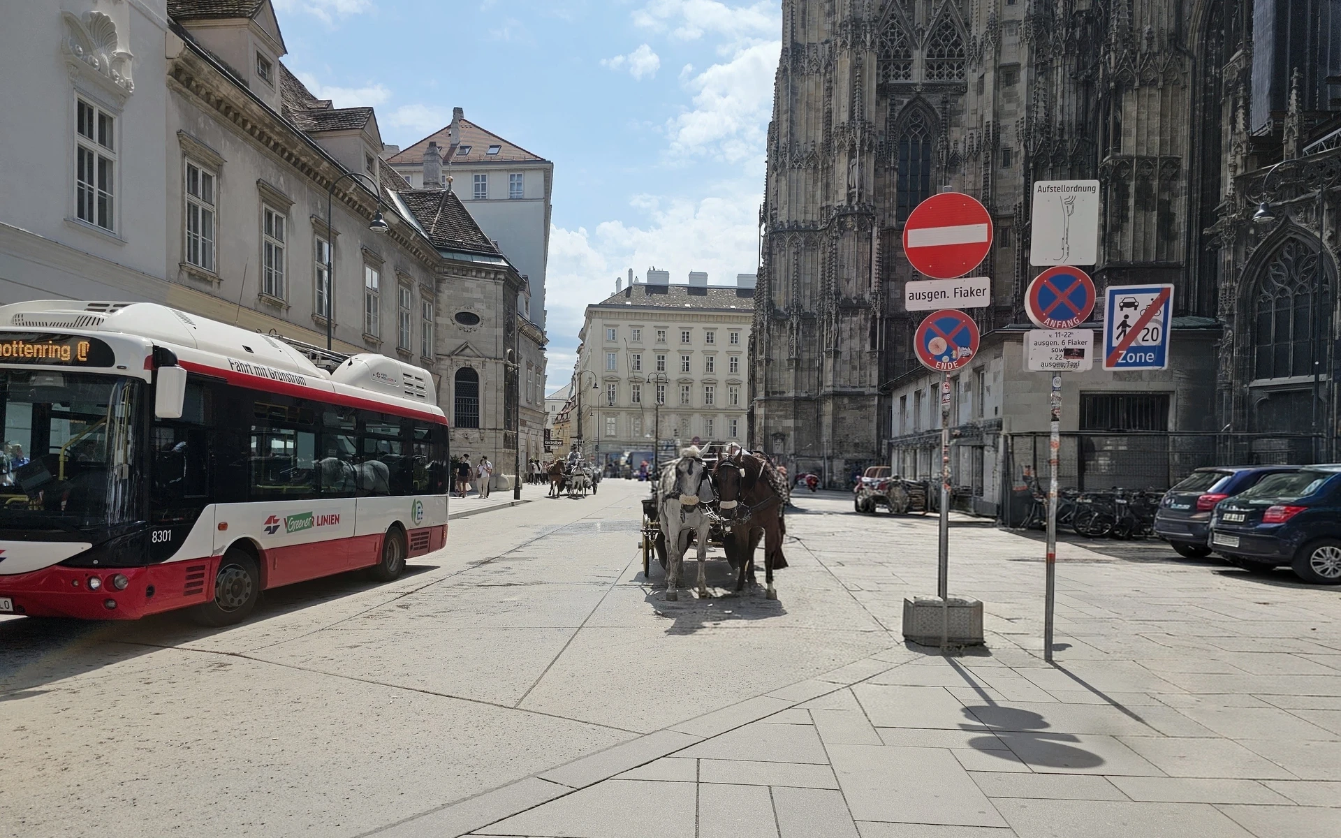
There is a particular kind of satisfaction in looking at a picture of a street and guessing its city before anything else tells you, just by reading a word on a sign, a building’s architecture, the colour of a bus, or the hat on a carriage driver. No app, no search, just the evidence in the frame and a chain of reasoning that holds. Those identification skills are learnable, and this guide walks through them the way I actually use them: clue by clue, on a real photo. Now if you already guessed that the above photo was taken in Vienna, then you may already possess some of those skills. Nevertheless, read further to see if you knew about them.
A note on the photos: the pictures on this page are my own, taken in Vienna in the summer of 2025. They are not stock images. The only edit is that the faces of passers-by were masked or removed with an AI tool for privacy; you may see some blurred objects which is the side-effect of using the AI editing tool. However, most of the information required to guess the city remains intact.
The method: treat it like a case, not a trivia question
The easiest mistake is spotting one dramatic clue and stopping there. It’s quite easy to guess Paris if the photo contains even a glimpse of the Eiffel Tower. However, most photos don’t contain the Eiffel Tower. They may contain a corner of a street, parked cars, a few signs, people and part of a building facade. Those ordinary details are where the answer usually is.
I work through every photo the same way:
- Scan the whole frame before guessing. List what is there before deciding what it means.
- Go from coarse to fine. Language gets you a country or region, road rules and signs narrow it, and something unique to the city closes it.
- Weigh slow clues over fast ones. Sign designs, road markings, transit liveries, and building materials change over years. Weather, parked cars, and most clothing change daily.
- Use landmarks to confirm. A famous building is a great check on a guess you have already made. But be careful when you only see a sliver of it.
- Want at least three independent clues pointing at the same place before you commit.
Decoding my Vienna photo, step by step
I know where I took the photo at the top of this page, of course. So here is how I would decode it cold, in the order I’d look at it, as if a friend had sent it to me with no caption.
Step 1: Scan the whole frame
Before reading anything closely, I list what’s there: a red-and-white single-decker bus on the left, two horses harnessed to a carriage in the middle of a wide, pale stone square, a cluster of road signs on poles to the right, a dark, heavily carved Gothic church wall behind them, pale classical facades down the street, a few parked hatchbacks, and people and another horse carriage in the distance. Shadows are short and sharp. That list already says “old European city centre, sunny day,” but it doesn’t say which one.
Step 2: Read the text
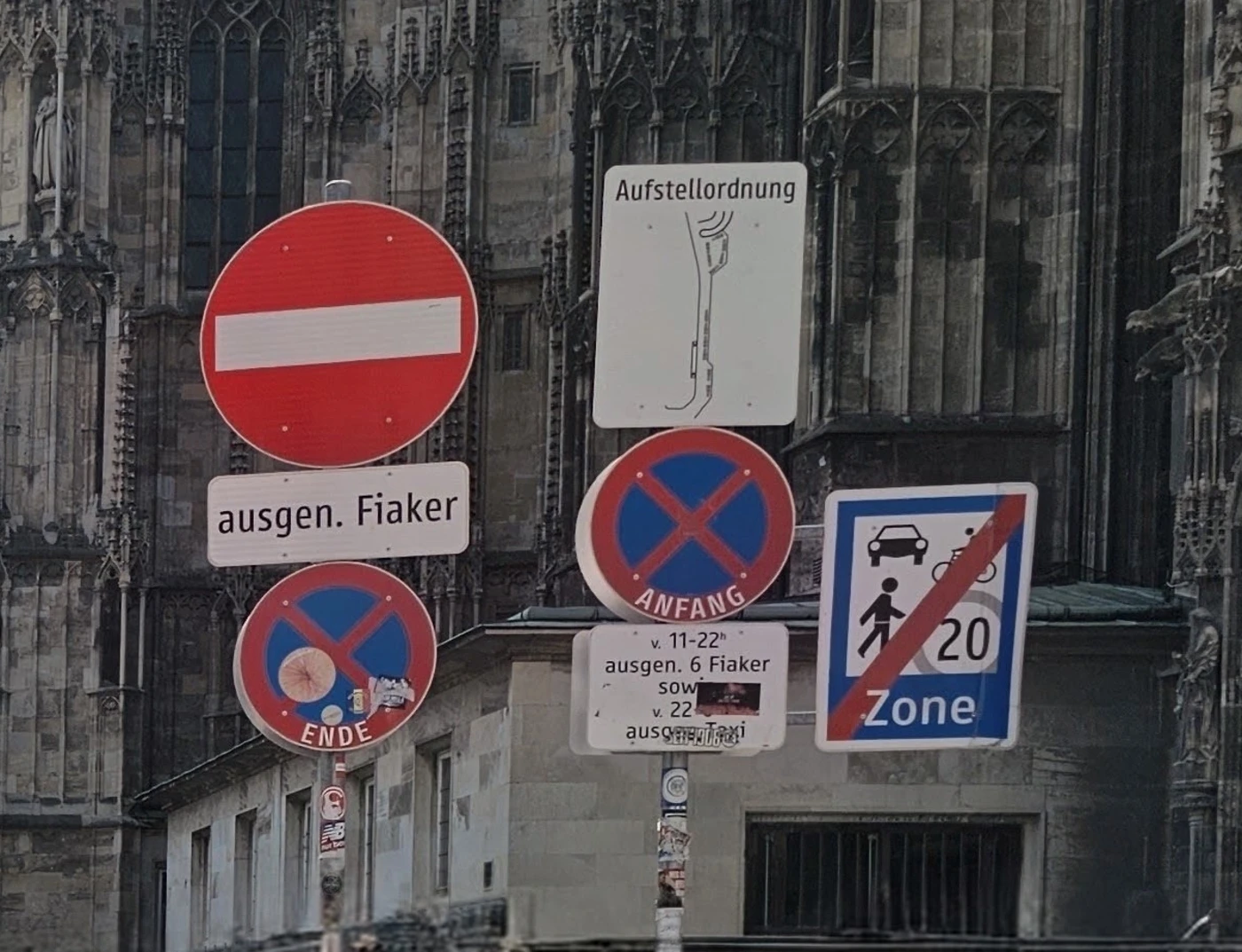
The signs read “ausgen. Fiaker,” “Anfang,” “Ende,” and “Aufstellordnung.” That is German, which narrows the field to the German-speaking countries: Germany, Austria, Switzerland, and Liechtenstein, plus pockets beyond them. Language is the fastest big cut you can make, but on its own it still leaves four countries.
Step 3: Read the regulatory signs
The red no-entry disc with a white bar isn’t much help. It is used across Europe, so it confirms “Europe” and nothing more. The blue square sign is more interesting: a pedestrian, a car, and “20 Zone,” crossed through with a red diagonal. That marks the end of a Begegnungszone, a shared street where, under Austrian road law, vehicles, pedestrians, and cyclists all use the carriageway with equal rights and a 20 km/h limit. Switzerland has a very similar 20 km/h Begegnungszone, so this sign narrows German-speaking Europe to roughly Austria or Switzerland. It doesn’t split them. Of course, one requires specialized knowledge about such street speed restrictions and rules. Without such knowledge the list of candidates still remains large.
Step 4: Find the one word only one city uses
This is the step that closes the case. The plaque under the no-entry sign reads “ausgen. Fiaker,” short for “ausgenommen Fiaker”: no entry, except Fiaker. A quick Google search will reveal that a Fiaker is a two-horse hackney carriage, and the name is tied to Vienna specifically. Vienna’s official tourism site calls them “just as much a part of Vienna as St. Stephen’s Cathedral and the Giant Ferris Wheel” and lists their inner-city stands, the first of which is Stephansplatz. A traffic sign that carves out an exception for horse-drawn carriages, in German, next to a 20 km/h shared zone, points hard at Vienna’s old town. The “Aufstellordnung” sign above it, which sets out where carriages line up, fits a regulated carriage stand in the same spot.
One word did more narrowing than the language, the architecture, and the road signs combined. That is the pattern to look for in any photo: the locally specific word, logo, or rule that doesn’t exist anywhere else.
Step 5: Look at the people and what they’re wearing
In the absence of such strong street signs, I look at the people in the picture. People are a clue I used to underrate. They come in two kinds, and they are worth very different amounts.
- Everyday clothing is weak but useful. The passers-by in the distance are in T-shirts, shorts, and sunglasses. That tells me it is the warm season and fits a tourist-heavy centre on a summer day. It doesn’t tell me which city, and on its own I wouldn’t give it much weight.
- Regulated dress can be decisive. The carriage driver further down the street wears a white shirt and a dark hat. In Vienna, that isn’t a fashion choice: the city’s operating rules for carriage businesses prescribe what drivers wear on duty, including a waistcoat, jacket, bow tie or tie, and a Melone (bowler hat). A uniform that a city writes into law is about as slow-changing as a clue gets.
The same logic works elsewhere: police uniforms, transit staff, school uniforms, and traditional working dress are often regional or even city-specific. Holiday crowds and fashion are not.
Step 6: Check the vehicles and transit
The bus is red and white with “Linien” on the side, the look of Vienna’s public transport operator, Wiener Linien. Its destination display ends in “…ottenring,” which fits Schottenring on Vienna’s Ringstrasse, and the side reads “Fahrt mit Grünstrom,” “a ride on green electricity.” It’s a small electric bus working the narrow old-town streets, which matches what local reporting describes for Vienna’s inner-city lines 2A and 3A, where small electric buses have run and are being replaced by hydrogen-electric ones. Transit liveries are one of the best slow clues there is: operators repaint fleets rarely, and the colours are usually unique to one city.
The parked cars carry white, EU-style plates, but they are too far away and too angled to read. That is fine; they’d only have confirmed “Austria” anyway.
Step 7: Use the architecture to confirm, not to identify
Only now do I look properly at the building behind the signs: dark, weathered stone, pointed arches, dense Gothic tracery. On its own, a fragment of a Gothic church could be in dozens of European cities. But after steps 2 to 6 have already pointed at the Fiaker stand at Stephansplatz, that wall is exactly what should be there: St. Stephen’s Cathedral. The architecture doesn’t make the identification. It confirms it.
Step 8: Verify before you commit
The last step is checking the guess against the real place. Open Google Street View or Apple Maps Look Around at Stephansplatz, Vienna, and match specific details: the sign posts, the paving pattern, the cathedral’s side wall, the pale buildings down the street. If they line up, the case is closed. If they don’t, go back to the clue that surprised you most.
Counted up, that’s more than three independent lines of evidence: the language, the Austrian or Swiss zone sign, the Viennese Fiaker exemption, the regulated Fiaker dress, the Wiener Linien bus, and the cathedral. No single one of them would have been enough.
Clue families to check on any photo
The Vienna photo happened to be rich in text. Many photos aren’t, so here are the families of clues I check, roughly in order of how much they tend to narrow things down.
Text and script. The script alone does a lot: Cyrillic, Arabic, Hebrew, Devanagari, Thai, and Hangul each point to a limited set of countries. Within Latin script, the words on regulatory signs, shopfronts, and street-name plates tell languages apart, and local abbreviations like “ausgen.” are often more specific than the language itself.
Signs and road rules. Sign shapes and colours follow national rules, so their design narrows the country even when you can’t read the text. Which side of the road traffic keeps to is another quick cut: the UK’s Highway Code tells drivers to “keep to the left, unless road signs or markings indicate otherwise”, while most of the world keeps right. Road-marking colour helps too. In the United States, yellow lines separate traffic travelling in opposite directions and white lines separate traffic in the same direction, so a yellow centre line is a strong North American hint, though not proof, since some other countries use yellow too.
Architecture and materials. Building materials, roof shapes, window styles, and how closely buildings sit together are slow to change and strongly regional. Treat them the way step 7 did: excellent for confirming a candidate, less reliable as the first clue, because many styles were exported far beyond their origin.
Street furniture. Bollards, lamp posts, utility poles, transit shelters, drain covers, and street-name plates are designed or procured city by city, and they are rarely replaced all at once. They are some of the most underrated clues in any street photo. Look for flags and emblems too: national or regional flags on public buildings, and city coats of arms on lamp posts, drain covers, bins, and municipal vehicles, can name the country or even the city outright. Just check whose flag it is, since hotels and embassies often fly foreign ones.
People and dress. As in step 5: everyday clothing gives you the season and climate, while uniforms and legally prescribed working dress can point to a single city. Be careful with crowds in tourist centres, which tell you more about the visitors than the place.
Vehicles and transit. Bus and tram liveries, taxi colours, and number-plate formats are all strong. Individual car models are weak, since the same models are sold almost everywhere.
Sun, shadows, and plants. Shadows can suggest a hemisphere, but only with care. North of the Tropic of Cancer, the midday shadow always points due north, and south of the Tropic of Capricorn it points due south. That only helps if you know roughly which way the camera faced and that it was near midday. In my Vienna photo the shadows are short and sharp, which says “near midday on a clear day,” but without a compass direction they can’t settle the hemisphere on their own. Vegetation adds climate: palms, dense conifers, or dry scrub each rule out a lot of the map.
Common mistakes when reading a photo
- Stopping at the first plausible clue. A red double-decker bus suggests London, but red double-deckers also run in other cities. One clue opens a hypothesis; several independent clues close it.
- Trusting fast clues. Weather, parked cars, and fashion change constantly and vary within a single city. They can support a guess but shouldn’t carry it.
- Starting from the landmark. If you only see part of a building, “it looks like a Gothic cathedral” matches too many places. Let the small clues build the case, then use the landmark to confirm it.
- Stopping at the country. “Austria” is not “Vienna.” Keep looking for the locally specific word, livery, or rule that gets you to the city.
- Skipping verification. A chain that feels convincing can still be wrong. Street View is the cheapest way to find out.
When your eyes run out: EXIF, Google Lens, and AI
Identifying the place in a photo isn’t only a game. For instance, journalists and fact-checkers need to verify where a viral image was really taken, travellers want to find a spot they saw in someone else’s post, and families try to place old holiday prints with nothing written on the back. In cases like these, getting the right answer is more important than the satisfaction of getting there by visual inspection. When the stakes are real, or when you need independent confirmation before relying on a guess, using the below-mentioned tools makes perfect sense. However, when the use-case is pure entertainment or learning, letting a tool answer first skips the part that is actually fun.
- Photo metadata. Photos taken on a phone often store GPS coordinates in their EXIF data, though social platforms usually strip them before posting. ExifTool can turn coordinates into a place name using its built-in database of cities with a population of 2,000 or more.
- Reverse image search. Google Lens matches a photo, or a cropped part of one, against images on the web, which works well for landmarks and widely photographed streets.
- AI place recognition. The research idea is older than it looks: in 2008, Hays and Efros at Carnegie Mellon showed with IM2GPS that a photo’s location could be estimated by matching it against over 6 million geotagged images, with results up to 30 times better than chance. Modern retrieval models such as MegaLoc do the same thing at far larger scale. Like any retrieval system, they are only as good as their reference imagery, so their answers still need the same Street View check as yours.
The same reasoning skills carry over to map-based quiz games, travel photography, and any situation where you want to know where a picture came from.
Put your eye to the test
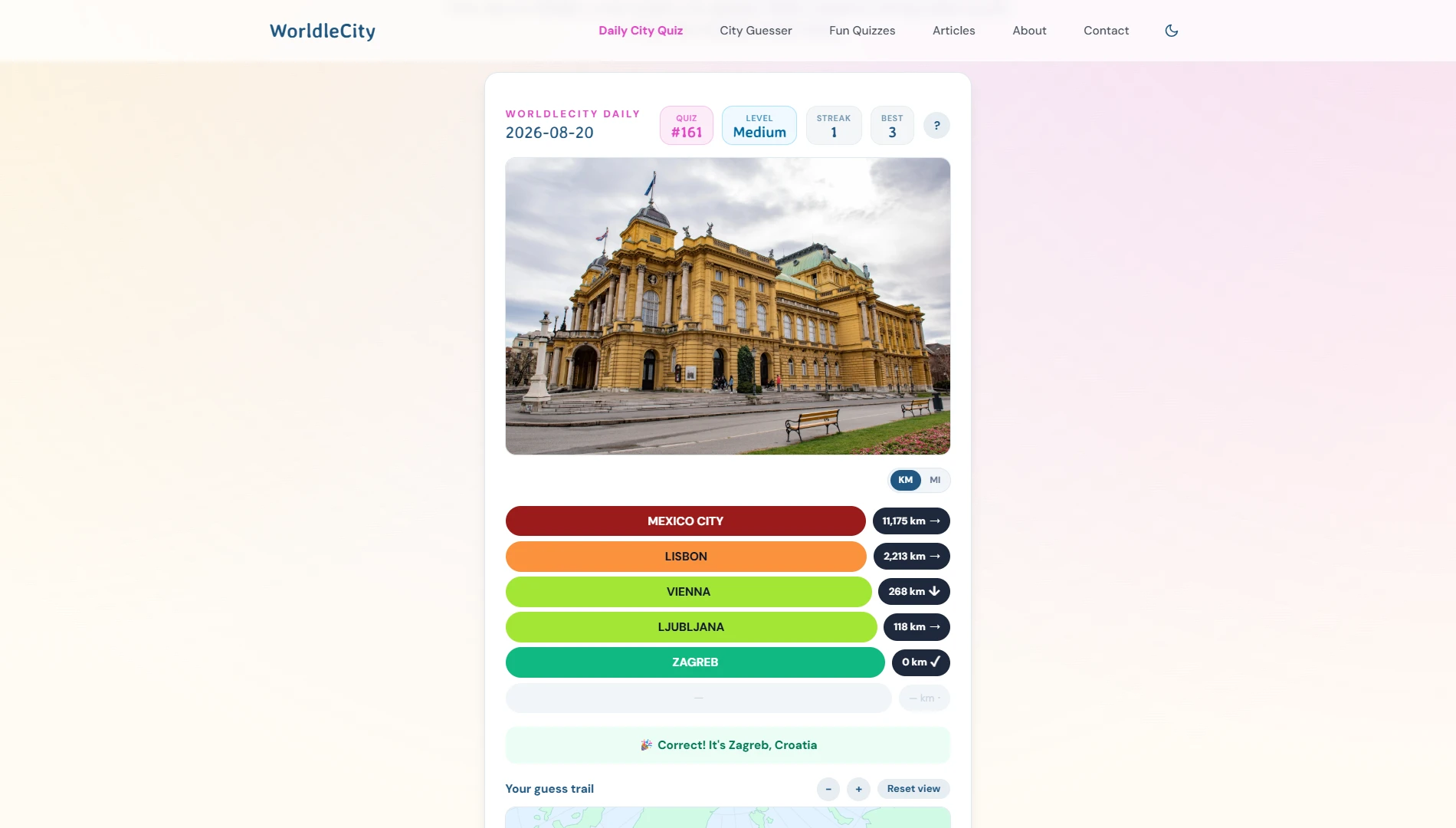
Everything above is exactly what WorldleCity’s daily game asks of you. You get one photo of a mystery city, no caption, no metadata, and no search box, just the frame and six guesses. After each wrong guess you get the distance and direction to the answer, so every miss becomes another clue to reason with. If you want more practice than one city a day, the City Guesser quizzes use the same photo-based idea across four difficulty modes, so you can start with easy wins and work up to scenes with far fewer clues. No account needed. If you want to train your eye to recognize cities from images, that is the most direct way I know to practise it.
Sources
- ExifTool: Geolocation
- Google Search Help: Search with an image on Google
- Hays and Efros, “IM2GPS: estimating geographic information from a single image,” CVPR 2008, Carnegie Mellon University
- Berton and Masone, “MegaLoc: One Retrieval to Place Them All,” arXiv 2502.17237
- oesterreich.gv.at: Begegnungszonen
- wien.info: Fiaker horse-drawn carriages in Vienna
- OTS: Fiaker-Betriebsordnung, rules for drivers and vehicles (2001)
- MeinBezirk: Hydrogen-electric buses on Vienna’s inner-city lines 2A and 3A
- GOV.UK: The Highway Code, using the road (rules 159 to 203)
- FHWA MUTCD 2009, Part 3A: Pavement markings
- EarthSky: The meridian, when does the sun cross it?
FAQ
How do I identify a city from a photo without any tools?
Scan the whole frame first, then work from coarse to fine: read any text to get the language and country, check regulatory signs, road rules, and any flags or emblems, then look for something only one city has, such as a local transport livery, a city coat of arms, a regulated uniform, or a locally specific word. Use architecture to confirm the guess rather than to make it, and verify on Street View before you commit.
What visual clues are most reliable for identifying a city?
Slow-changing clues are the most reliable: sign wording and design, road markings, which side of the road traffic keeps to, street furniture, transit liveries, and building materials. Weather, parked cars, and most clothing change too quickly to carry much weight on their own.
Can people and clothing help identify where a photo was taken?
Yes, in two different ways. Everyday clothing tells you the season and climate, which is useful but weak. Regulated dress is much stronger: uniforms and traditional work clothing that a city requires by law, such as the bowler hat worn by Vienna’s Fiaker carriage drivers, can point to a single city.
What if the photo has no text or signs?
Lean on road markings, the side of the road vehicles use, street furniture, vegetation, and building materials. Shadows can help too: north of the Tropic of Cancer the midday shadow points north, and south of the Tropic of Capricorn it points south, so shadows plus a known camera direction can suggest a hemisphere.
Should I use Google Lens or EXIF data to identify a city?
They are useful when you are stuck or need to confirm a guess. If a photo still has GPS metadata, a tool like ExifTool can turn it into a city name, and Google Lens can match a photo against images on the web. Try reading the clues yourself first, though; that is where the skill, and the satisfaction, comes from.