How to Triangulate a City From Compass Bearings
Learn resection and intersection, the two real navigation methods behind triangulating a position from compass bearings, and how GeoAngles turns the same skill into a game.
- triangulation navigation
- resection and intersection
- compass bearings explained
- map and compass skills
- land navigation basics
- GeoAngles
On this page

Triangulating a position from compass bearings isn’t a party trick. It’s a real navigation method with two names, resection and intersection, and it’s been used to find both hikers on a hillside and cities on a map for as long as compasses and maps have existed together. Learn the actual geometry and a game like GeoAngles stops feeling like guesswork and starts feeling like a puzzle you can reason through.
Resection vs. intersection: the two directions of the same idea
Both methods use the same tool, a bearing, but point it in opposite directions.
- Resection — you’re standing somewhere unknown. You take bearings out to two or three landmarks you can identify on a map, then draw a line from each landmark back along that bearing. Where the lines cross is you. This is the classic hiker-with-a-compass technique for figuring out your own position.
- Intersection — you’re standing at two or more known points. You each take a bearing toward the same unknown target, then draw a line from your position outward. Where those lines cross is the target.
Resection finds your own position from known points. Intersection finds an unknown point from your own known positions. They’re mirror images of each other, and converting between them is just a matter of flipping each bearing 180 degrees, known as taking its back bearing. A landmark that reads 40° from where you stand is being read as 220° from the landmark back toward you.
How to actually do it, step by step
The Ordnance Survey’s field method is a good real-world walkthrough, built for hikers doing resection with a map and compass, but the steps transfer directly to reasoning about any triangulation problem:
- Pick landmarks spread around you, not clustered together. Three features spaced roughly 120° apart, one ahead, one over each shoulder, give a far more reliable fix than three landmarks all sitting in roughly the same direction.
- Take each bearing carefully. Point the compass at the landmark and read the angle off the dial.
- Correct for magnetic variation if needed. A magnetic compass doesn’t point at true north, it points at magnetic north, and the gap between the two (magnetic declination) shifts by location and drifts slowly over time. Subtract it before plotting on a map that’s drawn to true or grid north.
- Plot the line, not just the point. Lay the bearing on the map from each landmark and draw the full line, not a guess at where it lands.
- Read the triangle, not just the crossing point. With three lines, you’ll rarely get one perfect intersection, you’ll get a small triangle. Wikipedia’s overview of resection and intersection calls this the accuracy check built into the method: the wider the triangle, the less you should trust the fix, and it explains why a bearing spread should avoid landmarks that sit near a single arc from your position, a configuration surveyors call the danger circle.
That small triangle of error has an informal name among navigators: the cocked hat, after the three-cornered hats it resembles. It isn’t a flaw in the method, it’s the method telling you how confident to be.

The bearing math underneath it
Every one of those bearings is really just an angle between two points on a sphere. For real geographic coordinates, that angle, called the initial bearing or forward azimuth, is computed from each point’s latitude and longitude using spherical trigonometry, the same great-circle math that Movable Type’s reference implementation documents in detail. You don’t need to run that formula by hand to use the concept. Every proximity-feedback game that shows you a compass arrow, including Worldlecity’s daily city game, is running that same calculation behind the scenes and handing you the result as a rounded angle.
Triangulating a city with GeoAngles
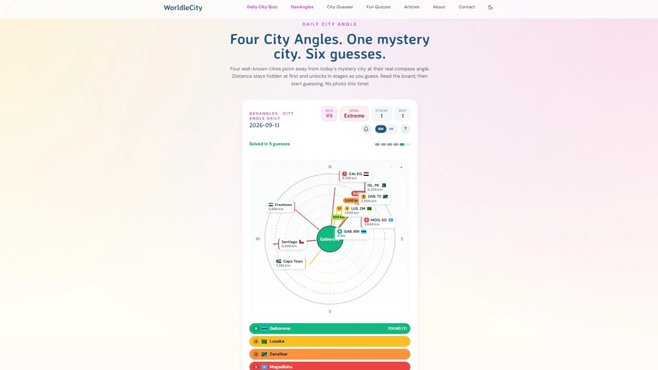
GeoAngles is a practical, low-stakes way to run this exact skill without a compass or a hillside. The board shows four known cities, each with an arrow pointing outward from the hidden mystery city toward that known city. That’s resection geometry, already computed for you, just pointed the opposite direction from how a hiker would use it.
Here’s the reasoning move that makes GeoAngles click: each arrow you see is a bearing from the mystery city to a known one. To use it the way a navigator would, flip it into its back bearing, the direction from the known city back toward the mystery one, and imagine that line drawn on a world map. Do that for two or three of the four known cities and you’re running intersection by hand, in your head, exactly like two lookouts triangulating a ship from a known headland. Where your mental lines would cross is roughly where the mystery city sits.
You get six guesses, and the board itself gets more precise as you use them: the mystery city starts fully hidden, then resolves through a distance-band color, then a rounded-to-500-km ring, then the exact distance, so even a rough first triangulation gets corrected round by round. You pick your answer from a searchable city list, so once you’ve narrowed the region, spelling is never what stands between you and the right guess. Try today’s board at worldlecity.com/geoangles, or practice the skill at your own pace, with a selectable difficulty, at worldlecity.com/geoangles/practice.
Why the skill is worth having beyond the game
Resection and intersection aren’t retired techniques. They’re still the backbone of land and inshore navigation whenever GPS isn’t available or isn’t trusted, precisely because the method only needs a map and an inexpensive compass to work. Learning to read a bearing as a line rather than a single number, and to spot when three lines agree with each other versus when they’re telling you to distrust the fix, is a genuinely transferable piece of spatial reasoning. A game board is just a faster, lower-stakes place to build the instinct before you ever need it on a hillside.
Sources
- Position resection and intersection — Wikipedia
- Pinpointing your location with bearings and triangulation — Ordnance Survey
- Calculate distance and bearing between two latitude/longitude points — Movable Type Scripts
FAQ
What’s the difference between resection and intersection?
Resection is when you stand at an unknown point and take bearings out to known landmarks to find your own position. Intersection is the reverse: you stand at known points and take bearings toward a single unknown target to find its position.
Why do you need three bearings instead of two?
Two bearings will already give you an approximate fix where the lines cross, but any small error in either bearing shifts that crossing point without warning you it happened. A third bearing usually misses the same point by a small amount, and that gap, called a cocked hat, tells you how much to trust the fix.
What is a back bearing?
A back bearing is a compass bearing rotated 180 degrees. If a landmark reads 40 degrees from where you’re standing, the back bearing, the direction from the landmark to you, is 220 degrees. Converting between the two is what lets you switch between resection and intersection using the same set of angles.
How does GeoAngles turn this into a game?
GeoAngles shows you the bearing from a hidden mystery city outward to four known cities, which is the resection geometry already computed for you. To find the mystery city, you mentally reverse each arrow into a back bearing running from a known city toward the hidden one, the same reversal a hiker does by hand, then guess where those reversed lines would converge.