Locate, Recognise, Deduce, Route: How Geography Guessing Games Work
Every geography guessing game is built from three choices: what you're shown, how you answer, and what feedback you get. Here are the four types they produce, with real examples of each.
- geography guessing games
- types of geography games
- GeoGuessr style games
- Worldle style games
- proximity feedback
- GeoAngles
On this page

Many geography guessing games look the same. They usually start with an unknown entity, a handful of guesses, and a hint after each miss allowing you to uncover the mystery. However, almost every such game is built from three design choices. What you’re shown before the first guess, what you answer with, and what you’re told back after a wrong guess. Vary any one of those and you will get a different game that tests a different skill.
I tried to simplify and sorted these geography guessing games based on what your first guess depends on, because the first guess is the only one you make before any feedback arrives. That gives four types.
| Type | Your first guess depends on | Examples |
|---|---|---|
| Locate | Placing the answer on a map | GeoGuessr, video guessers (Virtual Vacation, cityguesser.eu), Seterra (pin mode) |
| Recognise | Reading a photo, silhouette or flag | WorldleCity, Worldle, WhereTaken |
| Deduce | Clues or feedback | Globle, Countryle, GeoAngles, VisitWhale City Angle and City Route |
| Route | Knowing the neighbors and stitching a route | GeoFunGames Travel Route, Travle, Border Chain |
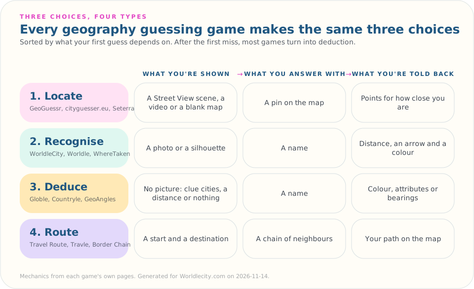
Most games are hybrids after the first guess. Once feedback arrives, almost every type turns into a deduction game. This is where you use your analytical skills and move further towards the answer.
Type 1: Locate, put it on the map
In a Locate game the answer is a position. You usually don’t name anything but point at it in a world map.
GeoGuessr is the best-known example. It places you in a Street View panorama and you guess where you are by marking it on a world map. Reading the scene is recognition, but because the answer is a point on a map, the game rewards knowing where things are, not just what they are called. A near miss still scores.
Video-based guessers swap the still panorama for moving footage. City Guesser on Virtual Vacation, running since August 2020, plays street-level video, and you click on the map to guess the place. It has worldwide and regional maps, plus challenges such as No Moving and a Time Limit mode where the video stops after a set number of seconds. (It has no connection to WorldleCity’s photo-based City Guesser, despite the shared name.) cityguesser.eu works the same way: you’re shown a video of a random location, place your guess on the world map, and earn points based on how close you are. Video gives you clues a still image can’t, such as which side of the road traffic keeps to and how people and vehicles move through a street. Video footage also keeps providing clues, so what seems like a hard one becomes easy because a road-sign or a shop’s name gave away the place after 10 seconds. However, in a video based guesser you can’t pause on a street sign that has already passed the camera unless the game lets you.
Map quizzes aimed for classroom and teaching are the simpler, older form of the same thing. Seterra, now part of GeoGuessr, offers its map quizzes in a Pin mode and a Type mode. Pin mode is Locate in its purest form where an unlabeled map is the whole clue, so the skill is spatial memory.
In Locate games, you can play a role similar to a detective in a crime scene. You can analyze the footage, or pan and zoom into the scene and look for visual clues to arrive at the first suspect. These games provide a unique experience because you are momentarily transported into the mystery location and you get to see the local conditions and find things which you may have never seen before.
Type 2: Recognise, name it from how it looks
A Recognise game shows you something like a picture or a country’s silhouette and asks you to name it. The first guess depends entirely on whether you are able to recollect the shown picture from your memory. Of course, you can also read the clues in the picture and make an informed guess.
The WorldleCity daily shows a photo of a monument, landmark or city skyline and gives you six tries to name the city, picked from a searchable city list. The City Guesser uses the same mechanic in sets of 10 cities, across four difficulty tiers (six tries per city on Easy, five on the harder tiers). Score 8 or more in a set and you can step up a tier.
Worldle does the same with a country’s silhouette instead of a photo: six guesses, one puzzle a day. WhereTaken uses the same mechanic of showing a photo just like Worldlecity. However, instead of guessing a city you guess the country of the place where the photo is taken.
Landmark and capital quizzes are the quiz-format cousin of this type. A landmark quiz is recognition (you see the Sagrada Família, you name Barcelona); a capitals quiz is recall (you see “Australia”, you produce “Canberra”). Recall is harder, because there’s no picture to trigger the memory, and a guessing game that gives feedback after a miss is more forgiving than either, because a wrong first guess still teaches you something.
Recognise games rely heavily on your memory. To identify a country based on its silhouette, you must have read the atlas or maps earlier. To recognize a landmark in a picture, you must have seen it somewhere or must have learnt about it earlier. Guessing the city based on a picture also involves photo-reading skills and this guide can come in handy.
Type 3: Deduce, find it without visual clues
Deduce games usually do not show you a picture of the answer. Your first guess is either a blind opener or a reasoned guess from abstract clues, and the game is won by reading the feedback well.
- Globle has a new mystery country every day. Each incorrect guess appears on a globe with a colour indicating how close it is. The hotter the colour, the closer you are. There’s no guess limit; the goal is to use as few as possible. There is another variation involving guessing the capitals instead of countries as well.
- Countryle compares your guess with the hidden country on five clues: hemisphere, continent, average temperature, population, and the direction of the hidden country from yours. It’s the closest geography gets to Wordle’s letter-by-letter feedback.
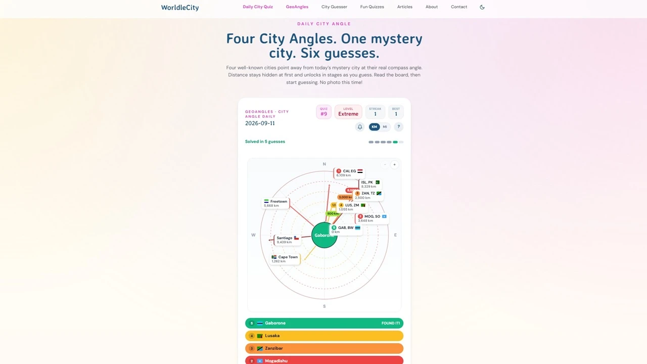
- VisitWhale City Angle shows five known cities, each with an arrow running from the hidden city out to that known city (even though the game’s FAQ section describes the other way round!). You get seven tries, and each wrong guess becomes an extra hint arrow on the board.
- VisitWhale City Route tells you how far the hidden city sits from a starting city and gives you seven guesses to find it. Each guess shows its distance to the target and draws your path across the globe, with closer guesses glowing warmer, and hints unlock as you go: population, direction, language, country, then the first letter. Each day’s hidden city becomes the next day’s starting point. This is similar to Globle’s capital city guesser deduction method.
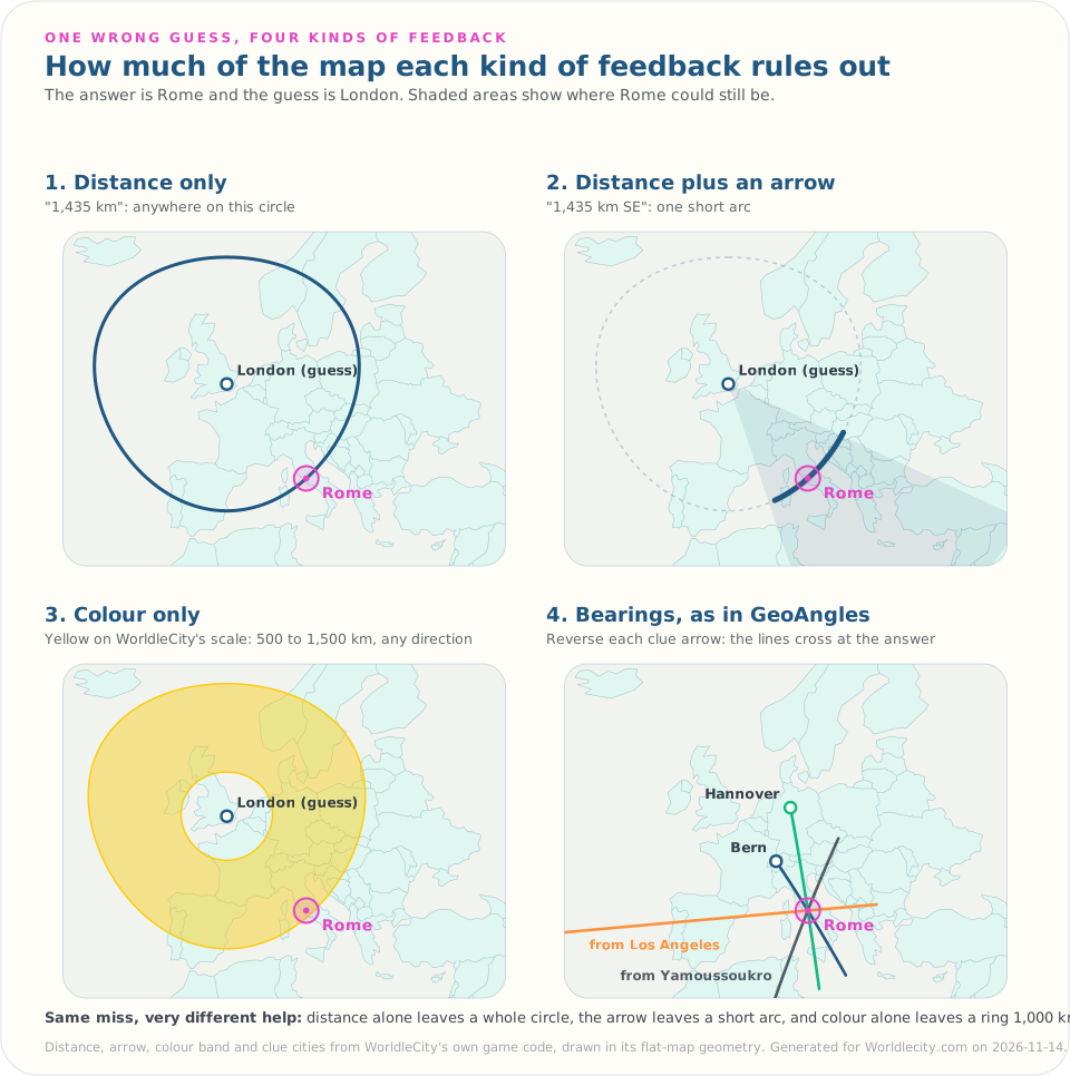
- GeoAngles, which I built for WorldleCity, uses the same outward-pointing arrows with four known cities instead of five. Because each arrow points from the hidden city out to a known city, you have to reverse it in your head before you can draw the lines and see where they cross (how to triangulate a city from compass bearings covers the method). You get six guesses, and the hidden city’s position resolves in stages: fully hidden, then a distance-band colour, then a ring rounded to 500 km, then the exact distance.
Type 4: Route, get from A to B
Route games give you a start and a destination and ask you to connect them. GeoFunGames Travel Route gives you a start country and a destination, and you type a country that borders the last one in your chain, aiming to complete the route in as few guesses as possible. Travle and Border Chain set a similar start-to-destination puzzle between two countries.
This is the only type where the answer isn’t a single place. It tests the knowledge of not just recognizing silhouettes but also the actual placement of the countries on a map and which countries actually share a border. Most people can find France and Austria on a map; fewer know offhand whether you can get between them without crossing Switzerland, Germany or Italy.
Feedback is the real difference
After the first guess, the feedback decides how the game plays. There are four common styles, and each one leaves something out.
- Distance only tells you how far, not which way. You can be 2,000 km off in any direction.
- Distance plus an arrow (Worldle, the WorldleCity daily) narrows the search to a wedge. WorldleCity also colours each guess by distance band: lime within 500 km, yellow within 1,500 km, orange within 3,000 km, red within 8,000 km, deep red beyond.
- Colour only (Globle) is the gentlest. It tells you hot or cold and leaves the direction for you to work out by comparing guesses.
- Attribute comparisons (Countryle) tell you about the place itself, not just where it is, so a guess on the wrong continent can still be useful if its population or climate is close.
What feedback doesn’t always tell you is the true distance. The shortest route over the Earth’s surface is the great-circle distance, which the haversine formula gives “as the crow flies”. WorldleCity’s games use a flat-map formula instead, the equirectangular approximation, which the same reference calls accurate enough “for many purposes” over small distances. I measured it across all 14,028 pairs of cities in WorldleCity’s library: for pairs under 1,500 km the distance is off by less than 0.1%, but at long range it can overstate the distance by up to 42% compared to the great-circle distance. The eight-way arrow differs from the great-circle starting direction in 42% of pairs. Near the answer, where precision matters, the error is negligible.
The other blind spot is the centroid. When distance is measured between two single points, such as the centres of two countries, a large country can read as hundreds of kilometres away from a neighbour it actually touches. City games have less of this problem, because a city is close to being a point.
Which type suits which player
| If you… | Try |
|---|---|
| Know what places look like | Recognise: the WorldleCity daily or the City Guesser |
| Know where places are | Locate: GeoGuessr, Virtual Vacation or cityguesser.eu for video, Seterra |
| Enjoy logic puzzles more than trivia | Deduce: GeoAngles, Globle, Countryle |
| Know your borders | Route: Travel Route, Travle, Border Chain |
Try the formats here
WorldleCity covers two of the four types. The daily city challenge and the City Guesser are Recognise games with distance, direction and colour feedback; GeoAngles is a Deduce game built on compass bearings, with a practice mode at your chosen difficulty. All three are free and need no account.
Sources
- GeoGuessr: Street View panorama, guess on a world map.
- Seterra: Pin and Type quiz modes.
- Virtual Vacation City Guesser and its About page: video footage, click-the-map guessing, challenge modes, August 2020 launch.
- cityguesser.eu: video of a random location, guess on a world map, points by closeness.
- Worldle: silhouette, six guesses, distance, direction and proximity feedback.
- Globle: How to Play, colour by proximity.
- Countryle: the five clues.
- VisitWhale City Angle and City Route.
- GeoFunGames Travel Route.
- MapGO Border Chain: daily, start and destination countries, land borders only.
- Movable Type Scripts, “Calculate distance, bearing and more between Latitude/Longitude points”: haversine, equirectangular approximation, initial bearing.
- Distance and arrow comparison: my own measurement over WorldleCity’s 168-city library, using the game’s distance and bearing functions.
FAQ
What are the main types of geography guessing game?
Sorted by what your first guess depends on, there are four: Locate games, where you place the answer on a map, from a Street View panorama (GeoGuessr), street-level video (Virtual Vacation’s City Guesser, cityguesser.eu) or a blank map (Seterra); Recognise games, where you name a place from a photo or shape (Worldle, the WorldleCity daily); Deduce games, where you find a hidden place from clues with nothing to look at (Globle, Countryle, GeoAngles); and Route games, where you chain neighbouring places from a start to a destination (Travel Route, Travle, Border Chain).
Which type of geography guessing game is best for beginners?
A Recognise game with feedback, such as the WorldleCity daily or Worldle. Your first guess only needs a hunch from the picture, and every miss returns distance and direction, so you can still reach the answer without recognising the place. Globle is also forgiving because it has no guess limit. Locate games like GeoGuessr and the video guessers are harder to start with, because each round rests on reading the scene before you get any help.
How do you use distance and direction feedback to narrow down a guess?
Treat each miss as a search area, not a failure. A distance and an arrow together put the answer roughly that far away in that direction, so your next guess should sit along that line at about that distance. Two misses from different directions usually cross close to the answer. In colour-only games like Globle, spread your first guesses far apart to find the warm region, then work inward.
Is the distance in these games the real distance?
Not always. Many games, including WorldleCity, use a flat-map approximation instead of the true great-circle distance. Across all 14,028 pairs of cities in WorldleCity’s library, that approximation is a median 2.3% longer than the great-circle distance, under 0.1% for pairs closer than 1,500 km, and up to 42% for the worst pair.
Do geography guessing games actually teach geography?
Each type exercises a different skill. Locate games train where things are, Recognise games train what places look like, Deduce games train reasoning with distance and direction, and Route games train what borders what. Playing more than one type covers more ground than playing one type a lot.